
Geographic map of Hungary
Geographic map of Hungary
Hungary is a member state of the European Union, established as a republic and located in central-eastern Europe, in the Pannonian Plain. The official language of this country is Hungarian.
Hungary is a parliamentary republic and is a member of NATO, the OECD, the Visegrád Group and the European Union, which it joined on 1 May 2004; it also signed the Schengen agreements.
Geography –
Hungary is located in Central Europe, in the Carpathian Basin, and is landlocked.
Its extension (93 thousand km²) is less than a third of Italy and corresponds to only 1% of the surface area of geographical Europe. The country extends for less than 300 km from North to South and more than 500 km from East to West.
The Hungarian territory is dominated by plains and gentle hills, two thirds of which are located below the level of 200 metres. The Hungarian mountains are modest in height, the highest point in the country is just above a thousand metres.
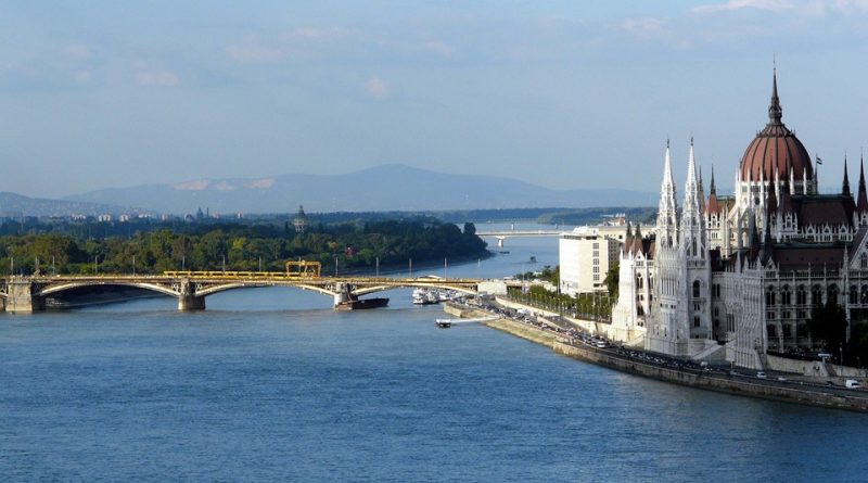
The country is crossed by the Danube, the longest river that flows in the territory of the European Union (over four times longer than the Po), and by the Tisza, the second largest river in Hungary (and in the EU). In the part of the country west of the Danube there is the largest lake in Central Europe, Balaton (over one and a half times larger than Lake Garda).
The country’s population is 10 million inhabitants (about one sixth of that of Italy) which constitute approximately 2% of the population of the European Union. Almost two thirds of the inhabitants live in cities.
The Hungarian capital is Budapest which is located in the northern part of the country and is divided in two by the Danube. Budapest has 1.7 million inhabitants and with this population, among those of Rome (2.8 million) and Milan (1.3 million), it ranks among the 10 largest municipalities in the European Union.
Other Hungarian cities are much less populous than Budapest. In fact, the second city by number of inhabitants is Debrecen with just over 200 thousand inhabitants (about the size of Trieste). The other seven Hungarian cities with a population exceeding 100 thousand inhabitants are in descending order by inhabitants: Miskolc, Szeged (Szeged), Pécs, Győr, Nyíregyháza, Kecskemét and Székesfehérvár.

Climate –
The climate of Hungary, a central-eastern European country located between 45 and 48 degrees north latitude, is continental, with cold winters and hot summers. The climatic differences between the different areas are limited, even if the climate is slightly more continental in the east, while in the south the winter is slightly less cold.
The average temperatures in January are around zero, and range from -1/-1.5 °C in the north-east (see Debrecen, Miskolc) to +0.5 °C in the south-west (see Pécs). In July and August, average temperatures are around 21.5/22 °C.
Precipitation is not abundant, but is distributed throughout the year. During winter, precipitation is quite frequent, and often occurs in the form of snow or sleet, while from May to August it occurs mainly in the form of thunderstorms in the afternoon.
The rainiest area is the west, where 600-700 millimeters of rain (or snow) fall per year, while in the rest of the plain 520-550 mm per year generally fall.
The sun in Hungary is seen quite rarely in winter, while in summer it shines quite often. On average there are almost 2,000 hours of sunshine per year in the north and almost 2,200 hours in the south.
On the shores of Lake Balaton, large but not very deep, you can expect less gray and slightly less cold weather in winter, except during frost waves, while in summer the breezes temper the heat a little. In summer, people bathe in the lake.
During the winter, from December to February, gray skies, mists and fogs are frequent. Snowfalls are not abundant but are quite frequent.
Sometimes, cold air masses coming from Russia can lower the temperature by several degrees, up to -20 °C at the worst times.
Summer, from June to August, is hot and sunny, although afternoon thunderstorms are quite frequent.
Sometimes, hot air masses from the south can bring heat waves that last a few days, with very high values, even above 35 degrees, generally in July and August, but sometimes also in June and September.
On the other hand, even in this season some Atlantic disturbances may pass, which can bring some cloudiness, coolness and rain.
The intermediate seasons are mild, but with possible temperature changes, especially in spring.
Flora-
Even in Hungary, human activity has drastically reduced and transformed the original natural environment. Despite this, Hungary’s natural heritage is still very rich and fortunately is now increasingly protected. Around 3,000 plant species and 43,000 animal species live in Hungary. More than 20% of the territory is protected area and the country has 10 national parks.
This natural heritage is a rare treasure of Europe. In fact, the Hungarian territory, with some smaller extensions in neighboring countries, constitutes the Pannonian biogeographical region, one of the nine biogeographical regions into which the territory of the European Union is divided based on homogeneous ecological characteristics.
Different types of plant communities extend as concentric circles from the center of the depression to the mountain slopes that bridge the outer boundary of the ecoregion. Right in the center, where the rain is almost completely blocked by the surrounding mountains, vegetation similar to that which characterizes the steppe grows. Moving away from the centre, we encounter forests of hornbeam (Carpinus spp.), Tatar maple (Acer tataricum) and turkey oak (Quercus cerris). On the mountainsides, forests of common elm (Ulmus minor), white poplar (Populus alba) and oak (Quercus robur) slowly take over. Along the Danube, which crosses the entire area, river forests and trees such as black alder (Alnus glutinosa), ash (Fraxinus spp.) and willow (Salix spp.) grow.
Fauna –
Due to the large variety of habitats available in this ecoregion, many different species of animals live here. BirdLife International has designated 50 Important Bird and Biodiversity Areas within the region’s borders. The wetlands provide refuge for spoonbills (Platalea alba), great egrets (Ardea alba), lesser harriers (Circus pygargus) and bustards (Otis bagna). Here also live species in danger of extinction such as the European mink (Mustela lutreola), the Orsini viper (Vipera ursinii), the horned viper (Vipera ammodytes), the snake-eyed skink (Ablepharus kitaibelii) and the Balkan lizard orientals (Podarcis tauricus). Among the mammals present here are the European hare (Lepus europaeus), the wild rabbit (Oryctolagus cuniculus) and the wolf (Canis lupus). Honey buzzards (Pernis apivorus) and goshawks (Accipiter gentles) are large birds of prey that feed on small mammals such as hares and rabbits. Ground-dwelling birds such as quail (Coturnix coturnix) hide in the tall grass and bushes. The Ural owl (Strix uralensis), the great-capped owl (Aegolius funereus) and the great swift (Tachymarptis melba) are widespread throughout the region.
Guido Bissanti