
Geographic map of Nicaragua
Geographic map of Nicaragua
Nicaragua is a Central American state, as well as the largest in the region after Mexico, with an area of 129,494 square kilometers.
From a geographical point of view, Nicaragua borders Honduras to the north and Costa Rica to the south, is bordered by the Pacific Ocean to the west and the Caribbean Sea to the east. Nicaragua is located in the northern hemisphere, at a latitude between 11 and 14 degrees north, in the tropical zone.
This country has a population of 6,327,927 inhab. (2016 Census) and its capital is Managua, with a population of 1,321,993 (as of 2016).
Geography –
Nicaragua is a country where almost a fifth of the territory is designated as protected areas, such as national parks, nature reserves and biological reserves.
It is a country rich in volcanoes due to its geological morphology. The territory, in fact, is crossed by a mountain range born from a very intense volcanic activity which led to the separation of the Caribbean Sea from the Pacific Ocean. Here are the so-called Marabios, about twenty volcanoes that arose in the Neozoic era. The territory of Nicaragua, therefore, to the east is still subject to tectonic adjustment and to eruptive and seismic phenomena with a volcanic arc that reaches from Panama to Mexico. Among the volcanoes we remember: Casitas, is remembered for an avalanche of mud that buried the city of Posoltega in October 1998, already heavily hit by hurricane Mitch; Cerro Negro, 675 m, is the most recent (arisen in 1850) and most active volcano, it has erupted several times in recent years (the last one in August 1999) and for this reason it is particularly dangerous; Concepción, 1576 m (see Maderas); Concho Cosigüina is now reduced to a vast caldera of about one kilometer in the promontory of Cosigüina, which closes the gulf of Fonseca, and it is what remains of a frightening explosion which in 1835 caused a shock felt thousands of kilometers away and rains of ashes for a radius of 1200 km. Hoyo Maderas, 1,329 m, twin volcano of Concepción to which it is connected by an isthmus, and with which it forms the island of Ometepe in Lake Nicaragua; Masaya, also known as Popogatepe, is part of a national park born in 1979, is currently active with a caldera composed of 13 crater cones and a lake, with gaseous and lava phenomena inside. In the past it was an object of veneration both for the natives and for the conquistadors who baptized it “Mouth of Hell”; Mombacho, rises on the shores of Lake Nicaragua, above the city of Granada and is part of the Reserva Natural Volcan Mombacho. It has been extinct for a long time so it is completely covered in vegetation that forms a particular ecosystem; Momotombo, 1280m, is responsible for violent eruptions that occurred in 1870 and 1886 which reduced it from over 1600m to its current height, it is located north of Lake Managua; Momotombito, flanks the Momotombo and emerges from the waters of Lake Managua; Rota San Cristóbal, also called El Viejo or Chinandega, is 1745 meters high and the highest volcano in Nicaragua; Telica.
From a hydrographic point of view, Nicaragua is a country with an important hydrographic network.
The eastern area is full of lakes that stretch along the slopes of the Marabios chain, the active volcanoes found along the country’s mountain range. The two largest lakes in the country form a single water basin as, in the past, they must have been an inlet on the Pacific Ocean coast which separated following eruptions and the deposit of lava material. Testimony of this nature is the fish fauna which hosts marine species adapted to fresh waters such as the tiburon, a shark up to 3 meters long. The most important lakes are: Lake Nicaragua, also known as Cocibolca, is 8,430 km² large and the largest in Central America, rich in islands of volcanic origin including the two volcanoes Maderas and Concepción on the island of Ometepe; Lake Managua, also called Xolotlan, is 1042 km² large and up to 30 meters deep, has a circular shape for which it is thought of a volcanic origin, communicates with the previous one through the Titi-tapa river, a connection which was interrupted in 1910 and which was reactivated in 1998 due to Hurricane Mitch; Laguna Apoyo owes its name to its brackish waters (Alt-poyec), its circular shape suggests that it was formed in an old volcanic crater. Thanks to these characteristics and its clear waters, it is rich in fish fauna and a tourist destination.
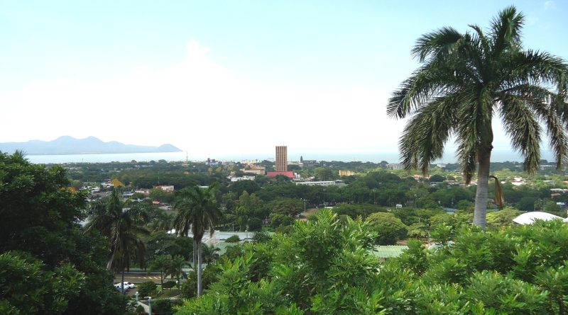
Due to its orography, Nicaragua can be divided into three geographical regions: the lowlands of the Pacific, the Amerrisque Mountains in north-central, and the Mosquito Coast on the Atlantic.
The Pacific lowlands are located in the western part of the country, these plains are large, warm and fertile. The plain is dotted with several large volcanoes of the Cordillera Los Maribios, including Mombacho just outside Granada, and Momotombo near León. The plain extends from the Gulf of Fonseca to Nicaragua’s border with Costa Rica south of Lake Nicaragua. Lake Nicaragua is the largest freshwater lake in Central America (nineteenth in the world), and is home to the only freshwater shark species in the world, the bull shark or Nicaraguan shark. This region is the most populous, with over half of the country’s population; there is the capital Managua, the most populous city and the only one with more than 1.5 million inhabitants.
The eruptions of western Nicaragua’s volcanoes, many of which are still active, have devastated the territory, but have also enriched it with layers of fertile ash. The geological activity that causes volcanism also generates strong earthquakes, which occur regularly throughout the Pacific area; Managua itself has been nearly destroyed several times by earthquakes.
The fertile soils and favorable climate make western Nicaragua the economic and demographic center of the country. The southwestern shore of Lake Nicaragua is 25 km from the Pacific Ocean; the lake and San Juan River were often proposed, in the 19th century, as the longest part of a canal through the Central American isthmus. These proposals have also been made periodically in the 20th and 21st centuries.
In addition to beaches and holiday resorts, much of the Spanish colonial heritage is also found in this region. Cities like León and Granada abound in colonial architecture and artefacts.
Then we have the area of the Amerrisque Mountains.
The Central Mountains are a significantly less populated and economically developed region located in the north, but extending to the southeast, between Lake Nicaragua and the Caribbean Sea. The region, at altitudes between 600 and 1500 metres, is a tierra templada, i.e. it has a climate with cooler temperatures than the Pacific plains, with daily maximum values of 24-27 °C; the rainy season is longer and wetter than in the Pacific region, making erosion a problem due to the steep slopes. Rugged terrain, poor soils, and low population density characterize the area as a whole, but the northwestern valleys are fertile and populated. About a quarter of the country’s agricultural sector takes place in this region, especially coffee is grown on the higher slopes.
Finally the area of the Atlantic plains.
This large rainforest-covered region is crossed by several major rivers and is sparsely populated. The Río Coco, which is the longest river in Central America, forms the border with Honduras. The coast on the Caribbean Sea is made irregular by lagoons and deltas, and is much more sinuous than that of the Pacific.
The Bosawás Biosphere Reserve in Jinotega is located in the Atlantic lowlands, and protects 7,300 km² of La Mosquitia forest (about seven percent of the country’s area), making it the largest rainforest north of the Amazon.
The east coast is very different from the rest of the country. Both the climate and the population are different. The population resembles that of the Caribbean more than that of the rest of Nicaragua.

Climate –
Nicaragua is a Central American country located just north of the Equator; it has a tropical climate, warm all year round.
The temperatures are quite stable, however there is a relatively cool winter from November to January, a very hot spring from March to May, and a muggy and rainy summer from May to October.
There is also a difference between the two sides: the western coast, facing the Pacific, is hotter and has a very pronounced dry season from December to April, while the eastern coast, facing the Caribbean Sea, is more humid and rainy . In fact, the latter, being exposed to the north-east trade winds, receives rain all year round, and therefore has a climate that can be defined as equatorial.
Consequently, the rains are very abundant on the east coast, from 3,000 to 4,000 millimeters (12 to 15 in) per year, while they are decidedly less abundant (about 1,200/1,300 mm) in the central plain, where the capital, Managua, and lakes Nicaragua and Managua. Along the western coast, facing the Pacific, rainfall amounts to 1,700/1,900 mm.
On the west coast it is hot all year round, even if there are sea breezes. The hottest period of the year is from March to May. There is a dry season from December to April and a rainy season from May to November.
The northern part, near the border with Honduras, is very hot, so much so that the temperature can reach 39/40 °C from March to May. Here are the average temperatures of Chinandega, located in the northwest, 13 km from the coast and 15 km from Mount San Cristóbal, which with its 1,745 meters is the highest volcano in Nicaragua.
In the southern part, the coast is a little less hot, also due to the presence of Lake Nicaragua (or Cocibolca), which however increases the humidity.
In Rivas, 1,700 mm (67 in) of rain fall per year, with a dry season from December to April, and heavy rains from June to October.
On the Pacific coast, the sea is warm enough for swimming all year round. Here is the sea temperature in San Juan del Sur, located on the coast near Rivas.
Managua, the capital of Nicaragua, is located at 12 degrees north latitude and 50 km from the sea, near a lake that supplies humidity, and is a particularly hot city.
The hottest days of the year are recorded before the rains, from March to May, when temperatures can reach 37/38 °C, especially in El Niño years, such as 1998 and 2016, which are particularly hot. In May, the first rainy month, the rains gradually begin to lower the temperature. In the June-November period, the maximum temperatures are around 32 degrees, but the humidity is higher.
It’s never cold at night. From November to March, on the cooler nights, the temperature usually drops to 18/20 °C, but occasionally it can drop to 15/16 °C.
In Managua, 1,200 mm (47 in) of rain fall per year; the dry period, which runs from December to April, is decidedly accentuated, so much so that it almost never rains. In the rainy period, from May to mid-November, the rainiest months are June, September and October, when more than 200 mm (8 in) fall per month.
The sun in Managua often shines in the dry period, while in the rainy period it shines for a few hours a day.
Nicaragua, as mentioned, is known as the land of lakes and volcanoes. Some volcanoes sprout from flat lands, such as San Cristóbal, others from lakes, such as Concepción, which emerges from Lake Nicaragua. In the central-northern inland area there is a mountain range, the Cordillera Chontaleña. The climate becomes mild above 1,000 meters of altitude, in the so-called tierras templadas.
In Jinotega, located in the northwest at 1,000 meters above sea level and colloquially called “the city of the mist”, on cooler nights the temperature generally drops to 14/15 °C from December to March, but can sometimes drop to at 11/12 °C. From March to May, on the hottest days, the temperature usually reaches 30/32 °C. Here are the average temperatures.
Flora-
In Nicaragua the abundance of biologically significant and unique ecosystems contributes to Mesoamerica’s designation as one of the biodiversity hotspots.
Nicaragua is one of the largest countries in Central America with a diverse and beautiful landscape including volcanoes, unique freshwater habitats (including Lake Nicaragua, the largest lake in the region), and spectacular marine environments off both coasts very different in the country. The country is also characterized by seven different forest types, from tropical rainforest, rainforest and mangrove to tropical dry forest.
Rainforest in Nicaragua covers more than 20,000 km², especially on the Atlantic lowlands, and is protected in the Bosawás, Jinotega Biosphere Reserve (in the north) and Indio Maíz Biological Reserve (in the south), which protects 2,500 km² of forest Atlantic rainwater.
The vegetation of Nicaragua is tropical or sub-tropical; pines, mahoganies, cedars, quebracho and guayacanes, the rubber tree and about fifty species of fruit trees abound.
Then we have the area of the Amerrisque Mountains. In this area are abundant oaks, pines, mosses, ferns and orchids that grow in the forests of the region.
Wildlife –
Nicaragua’s diverse environments support an incredible diversity of wildlife, many of which are found only in this country, including amphibians such as the Ometepe salamander, confined to the island of that name.
The country is also an important bird area, particularly in Ometepe. This UNESCO Biosphere Reserve, located in the middle of Lake Nicaragua, is home to the largest remaining population of the endangered yellow-naped parrot and is home to 170 bird species, 55 of which are migratory.
In addition, Nicaragua’s beaches also provide critically important nesting habitat for hawksbill, leatherback and olive turtles.
Many areas are rich in biodiversity. There are five species of big cats, including jaguars and pumas; three primate species, spider monkeys, howler monkeys and capuchin monkeys; a species of tapir (Tapirus bairdii), called Danto by the Nicaraguans, three species of anteaters and many others.
You can often meet pumas, jaguars, deer, peccaries, various species of monkeys and reptiles; there is a great variety of parrots, in particular macaws – called lapas – hummingbirds and wild turkeys.
Eumomota superciliosa, known in Nicaragua as guardabarranco and in English as blue-browed motmot, is the national bird.
Finally the area of the Atlantic plains.
A wide variety of birds can be observed in this region, including eagles, turkeys, toucans, parrots and macaws.
Birdlife includes resplendent quetzals, black-backed siskins, hummingbirds, jays, and toucans, Cyanolyca pumilo.
The fauna of the region also includes several species of monkeys, anteaters, white-tailed deer and tapirs.
Sadly, much of Nicaragua’s biodiversity is in danger of disappearing. Despite the Nicaraguan government’s best efforts to protect its wildlife, habitat loss (due to poverty and population growth), poaching, and climate change are putting pressure on the country’s habitats.
Guido Bissanti