
Victoria Island
Victoria Island
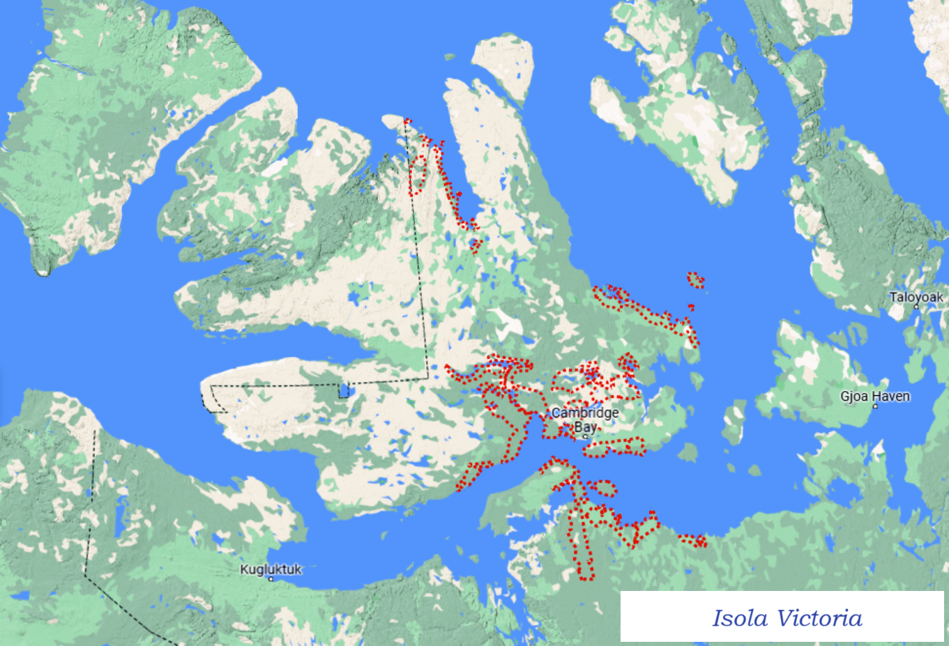
Victoria Island is one of the Canadian Arctic islands which, with its 217,291 km², is the eighth largest island in the world and the second largest in Canada.
Etymology –
Victoria Island is named after Queen Victoria who was ruler of the United Kingdom from 1837 to 1901, in the period known as the Victorian era.
Geographical Features –
The geography of Victoria Island is that of a very rugged territory in which we find the Viscount Melville Sound to the north, while the M’Clintock Channel and the Victoria Strait are located to the east.
To the west we find Amundsen Gulf and Banks Island, separated from Victoria by a long bay called Prince of Wales Strait. To the south (west to east) are the Dolphin and Union Straits, Austin Bay, Coronation Gulf, and Dease Strait.
The southern waterways, and sometimes the Prince of Wales Sound, are part of the disputed Northwest Passage that the Government of Canada claims are internal Canadian waters, while other nations argue are territorial waters or international waters.
Victoria Island is an island with a very marked coastline full of coves. To the east, pointing north, is the Storkerson Peninsula, which ends in Goldsmith Channel, the body of water that separates Victoria from Stefansson Island. The Storkerson Peninsula is separated from the north-central areas of the island by Hadley Bay, being a main inlet. To the north lies another large peninsula, the Prince Albert Peninsula. This ends in Prince of Wales Strait. To the south, and pointing west, is the Wollaston Peninsula, separated from the central areas of the island by Prince Albert Sound.
The highest point on Victoria Island is 655 m, in the north-central region. Located in the southeast, just north of Cambridge Bay, is Tahiryuaq (formerly Lake Ferguson). With a surface area of 562 km, it is the largest lake on the island.
Historical Notes –
Victoria Island was inhabited by the Thule culture, with five prehistoric qamutiik (sleds) belonging to the Neoeskimo culture found on the Wollaston Peninsula, dating from 1250-1573 AD. The Inuinnaqtun name for the island is Kitlineq, while the local Inuit population is called Kitlinermiut (Copper Inuit).
In 1826 John Richardson was the first European to see the south-west coast and named it “Wollaston Land”. In 1839, Peter Warren Dease and Thomas Simpson traced its south-eastern coast and named it “Victoria Land”. A map published by John Barrow in 1846 shows a completely blank space from these two lands north to “Banks Land”, which is the northern coast of Banks Island. In 1851 John Rae mapped the entire southern coast and connected the two “lands”. In 1850 and 1851 Robert McClure circumnavigated much of Banks Island, thus separating it from the rest of Victoria Land. His men also mapped the northwestern and western coasts of Victoria Island. One of Roald Amundsen’s men, Godfred Hansen, traced its east coast to Cape Nansen in 1905, and in 1916 and 1917 Storker T. Storkerson, of Vilhjalmur Stefansson’s Canadian Arctic Expedition, traced its north-east coast, sighting the Storkerson Peninsula.
In 2008 Clark Carter and Chris Bray became the first recorded people to cross Victoria Island. Their first attempt at the 1,000km trek in 2005 failed, so they returned and completed the remaining 660km in 2008.
Victoria Island has a polar climate, with no month having an average temperature of 10 °C (50 °F) or higher, and is listed as ET in the Köppen climate classification. Summers are generally cool and rainy, with pleasant days and cold nights. Winters are cold, dark and long, with October being the snowiest month. Snowfall and frost are possible all year round. Precipitation is usually limited to the summer months, when temperatures briefly rise above freezing for a few months before falling again for another 9 winter months. Spring is generally sunny but still very cold. Autumns are short and crisp, with more frequent cloud cover starting to appear in August and September which is almost constantly cloudy.
In Cambridge Bay, the sun is continuously below the horizon, polar night, from approximately November 30 to January 11 and above the horizon, midnight sun, from May 19 to July 22.
Ecosystem –
Victoria Island is characterized by a very particular ecosystem both for its climate at the extreme of possible conditions for flora and fauna species and for the presence of ice and snow for most of the year.
It is still a fairly virgin island even if it is affected by recent climate changes and the increase in temperatures which could, in the short space of a few years, alter a rather delicate ecosystem.
Flora –
In the Arctic regions of the Northwest Territories, climate patterns that include cold temperatures, a short growing season and glaciation just 10,000 years ago result in less diversity. Plants and trees have adapted to an extreme climate and a thin layer of useful soil. Willows and alders are the most common shrubs. Lichens, which provide food for caribou, join mosses and heathers like Labrador tea and berry-laden plants like blueberries to provide dense ground cover throughout the region. Flowers abound throughout the season with the most prolific displays in spring and early summer with clusters of arctic lupine, moss campion, mountain avens, fireweed, river beauty, pea and twin flowers.
Species of the local flora include: Arctic lupine Lupinus arcticus, aspen Populus tremuloides, bearberry or kinnikinnick Arctostaphylos uva-ursi, creeping dogwood Cornus canadensis, blackberry Rubus chamaemorus L, lilac Syringa vulgaris, lingonberry Vaccinium vitis-idaea, dandelion taraxacum officinale, white birch or canoe birch Betula papyrifera,
Fauna –
The small level of diversity found in ecosystems provides habitat for a surprisingly diverse number of birds and mammals. Mammals range from large land animals, including dryland and forest caribou, brown and black bears, moose, and musk ox, to smaller varieties of red fox, wolverine, lynx, ermine, arctic hare, and arctic ground squirrel or sicsic . Birds are plentiful, although birds such as thrushes, kingfishers, robins and other songbirds, and land birds such as grouse and ptarmigan are sometimes difficult to spot. Among birds, large birds of prey such as golden and bald eagles, ospreys, goshawks, peregrine falcons and gyrfalcons are most commonly seen. Jaegers, ravens, Arctic terns and gulls spend time on the rivers. Shorebirds, including plovers, sandpipers and grebes, eiders and mergansers are evident in most regions.
The Union Dolphin Caribou herd known locally as Island caribou is a migratory population of dryland caribou Rangifer tarandus groenlandicus, occupying Victoria Island in the Canadian High Arctic and the nearby mainland. They are endemic animals of Canada. They migrate through the Dolphin and Union Straits from their summer grazing areas on Victoria Island to their winter grazing area on the Nunavut-NWT mainland. It is unusual for North American caribou to cross sea ice seasonally, and the only other caribou that do so are the Peary caribou, which are smaller in size and population, and are also found on Victoria Island.
Environmental Protection Actions –
In the 2016 Canadian census, the island’s population was 2,162; 1,766 in Nunavut and 396 in the Northwest Territories. Of the two settlements on the island, the larger is Cambridge Bay, which is located on the southeastern coast and is located in Nunavut. Ulukhaktok is located on the West Coast and in the Northwest Territories. Trading posts, such as Fort Collinson on the northwest coast, have long been abandoned.
Even if the population of this immense island is very limited, however, like other territories, Victoria Island is affected by climate changes about which local populations can do little.
The retreat of some ice floes and snow cover is probably due to the increase in temperatures, so this situation must be monitored in the years to come.
Guido Bissanti