
Yellow River
Yellow River
The Yellow River also known as: 黃河, 黄河, Huáng Hé, Huang Ho or Hwang Ho, is the major river of northern China.
This river has a length of 5464 km and is one of the longest rivers in the world as well as the second longest river in China.
This river subtends a catchment area that covers an area of approximately 750,000 km², making the Yellow River the third largest river in the country.
Etymology –
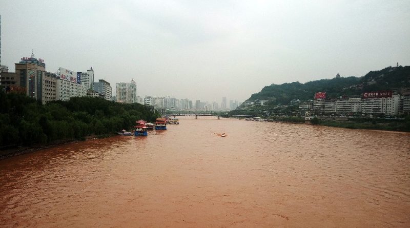
The Yellow River (Huang He in Chinese) owes its name to the fact that it crosses a plateau formed by a very fine material – almost powder – yellowish, called löss; the river erodes the löss and carries it downstream in enormous quantities (more than one and a half billion t of silt per year), turning yellow.
Geographic Features –
The Yellow River originates in Qinghai province on the Tibetan Plateau and passes through six other provinces and two autonomous regions on its way to Bo Hai (Gulf of Chihli), an inlet of the Yellow Sea. In its lower reaches it is a somewhat changeable and turbulent silt-laden stream which often bursts its banks, inundating part of the North China Plain. For this reason, it has also been dubbed the “sorrow of China” and the “Ungovernable”.
The Yellow River basin is home to a very large population – surpassed only by that of a small number of countries – and the river and its tributaries pass through some of China’s oldest cities, such as Lanzhou, Baotou, Xi’an (Sian), Taiyuan, Luoyang, Zhengzhou, Kaifeng and Jinan.
From a hydrographic point of view it is divided into three distinct sections: the upper mountainous course, the middle course through a plateau, and the lower course through a low plain.
The upper course is characterized by the stretch where the Yellow River has its source at an altitude of 4600 m in the Bayan Har mountains, in the eastern sector of the Tibetan plateau. In this section it crosses two large bodies of water, the Ngoring and Gyaring lakes. These shallow lakes, each about 1000 km² in area, are rich in fish and their surface freezes during the winter. The Yellow River in this region generally flows from west to east. The large plateaus through which the upper reaches rise 300–500 m above the river and its tributaries. These plateaus are made up of crystalline rocks which are sometimes visible as eroded outcrops on the surface.
The middle course, which has a length of 2900 km, consists of a large loop and drains an area of approximately 60,000 km². The river initially flows northeast for about 880 km through the sandy soils of northern Ningxia and western Ordos Desert; here it has many rapids, and in a number of places its width is considerably narrowed. The river then turns east and flows another 800 km through the floodplains of Inner Mongolia, in places where it branches into numerous distribution channels. In this section its slope is less than 9 cm per km, and many of the canals have been dug over the millennia to irrigate the fields. The Yellow River then suddenly turns south and flows about 715 km, forming the border between Shaanxi and Shanxi provinces.
In the middle reaches, the width of the river generally does not exceed 45–60 m, since it has to fight its way through narrow gorges with steep slopes of more than 100 m in height. The river then gradually widens, especially after receiving the waters of its two longest tributaries: first the Fen River of Shanxi Province and then the Wei River of Shaanxi. At its confluence with the Wei, the river suddenly turns eastward for another 300 miles (480 km), being forced to flow through the inaccessible gorges between the Zhongtiao Mountains and the eastern foothills of the Qin (or Tsinling) Mountains. The average gradient in this section slightly exceeds 20cm per km and the river becomes incredibly rapid in the last 160km before reaching the North China Plain near the city of Zhengzhou.
In this stretch, characterized by deep erosions and gorges, it crosses stratified rock systems in thick layers of more or less loose and incoherent soils, mainly made up of sand and loess deposited by the wind. The loess layers reach a thickness of 48–60 m and in some places even 150 m. Through these loose deposits the river has carved deep valleys, eroding and carrying huge amounts of surface material, making the region one of the most eroded landscapes in the world. The instability of the river bed is due to the easily eroded loess soil, both in the middle basin, where erosion is considerable, and in the plain, where the transported deposits create the deposit and channel bed.
The lower reaches are downstream from Zhengzhou where the Yellow River widens to flow through Henan and Shandong provinces across the North China Plain. This plain was formed over more than 25 million years as the Yellow River and other rivers deposited huge amounts of silt, sand and gravel in the shallow sea that once covered the region. The plain has been densely inhabited for millennia and was one of China’s major agricultural regions for a long time. The river has changed its course across the plain several times, and the inhabitants of the region have built extensive systems of levees and irrigation channels in an attempt to control the flow of the river. The region illustrates perhaps better than anywhere else on Earth how human activity has collaborated with natural forces to shape the landscape.
This stretch is about 700 km long and has an average gradient of about 5 cm per km. Finally we arrive at the delta of the Yellow River which begins about 80 km from the mouth and extends over an area of about 5400 km². The delta terrain is marshy, made up of mud and silt, and is covered in reed beds.

Historical Notes –
In Chinese history, the Yellow River is not only a waterway, but is regarded as the origin of culture and civilization. Hence the nickname “cradle of Chinese civilization”. The Yellow River, in fact, was fundamental for the development of the first cities and the first dynasties, even earlier, for the first prehistoric human settlements, moreover it was the political, economic and cultural center of China for at least 3000 years.
The Chinese refer to the Yellow River almost as a Mother Goddess, which since the Xia (2100–1600 BC) and Shang (1600–1046 BC) dynasties has become the richest, most prosperous and most conducive area for the development of civilization and of the Chinese Empire. However, according to historians, the Yellow River played an important role in what will be Chinese civilization even in earlier eras.
It is above all due to recent archaeological finds that we know that 2 million years ago Homo Pekinensis already lived in the area of the Yellow River basin. Subsequently, the first dynasties in Chinese history, Xia, Shang and Zhou (1046 – 256 BC), settled and founded the first capitals in present-day Henan province, Luoyang and Anyang area. It is from this period that the Chinese civilization of the Yellow River Basin begins to expand by merging with other prehistoric cultures and civilizations that inhabited other regions of China.
After the fall of the Zhou dynasty, Qin Shihuang unified all territories under the name of a single empire with a capital
Moreover, Xi’an, on the banks of the Wei River, a tributary of the Yellow River is the city that remains the political and cultural center even in later times, up to the Tang Dynasty (618–907 AD), reinforcing the importance of the River basin Development Yellow for the culture, economy and politics of the Empire of China.
Unfortunately, the Yellow River, also nicknamed “China’s pain”, has been responsible for the deaths of millions of people throughout Chinese history, due to disastrous floods and changes in its course.
The Yellow River Basin has always been subject to devastation from uncontrollable river waters, despite numerous works to strengthen levees and build dams. Historians have estimated that from 602 to 1946, the Yellow River flooded 1,593 times, resulting in deaths not only from drowning, but also from disease and starvation. The 1931 flood is considered the worst natural disaster ever recorded in Chinese history: estimated deaths range from 1 to 4 million.
Several times in history, the Yellow River has changed its course causing other disasters. It is estimated to occur about once every 100 years. About 3,000 years ago, the mouth of the Yellow River was near Tianjin, about 200km north of where it is now. In the last 1000 years it has also moved south, flowing as a tributary into the Blue River about 600 km from the current delta.
Ecosystem –
The Yellow River basin is characterized by one of the most distinctive ecosystems on the planet. The Yellow River lowland mixed forests are an ecoregion of the Palearctic ecozone of China.
The rich deposits of sediments carried by the Yellow River over the millennia indicate that the North China Plain is particularly fertile and suitable for agriculture. Because this area has been farmed for so long, much of the Yellow River lowland mixed forest has been cleared, but the ecoregion still contains a diverse range of habitats. The wetlands present here, for example, constitute a refueling stop for many migratory birds.
Overall this river has been a habitat for more than 125 varieties of fish, of which one fish is coveted on the National Conservation List of Key Aquatic Wildlife. There are parasitic algae, invertebrate animals and carnivorous fish in the river. It has also been the natural habitat of many bird species, such as Scaliger fusansers and red-crowned cranes. Due to the dense human population there is not much in the way of wildlife existing in the upper river basin. However, Tibetan antelope, wild yak, musk deer and Sikas can be spotted in the lower basin.
Flora –
The small fragments of native forest, which we find in the catchment area of the Yellow River, consist mostly of deciduous trees such as oaks, elms and pistachios. However, nearly all of these forests have been replaced by red pine forests. Conifers and cypresses grow on the highest mountains. Native conifers and other pine and larch species were introduced from other areas and now grow in place of the original forest cover. During the Pleistocene, the era that began about 1.6 million years ago and ended about 10,000 years ago, the Shandong peninsula was connected to the Dalian peninsula, located further north. As a result, forests characteristic of northeastern China grow there, with native oaks, lindens, and conifers, along with introduced species.
Wildlife –
The Shandong peninsula is a nesting area for protected birds such as the sea eagle (Haliaeetus albicilla) and the great bustard (Otis tarda). Rongcheng and Nansi Hu nature reserves are visited by migratory waterfowl, including swans, cranes and scaly merganser (Mergus squamatus). Protected mammals in this ecoregion include leopards (Panthera pardus) and sika deer (Cervus nippon). The Shandong Peninsula is a nesting site for seabirds and a wintering site for migratory waterfowl; there are also eight species of plants considered in danger of extinction.
Environmental Protection Actions –
The limited extent of protected land existing in this region is currently covered by secondary bush and grassland. There is no protection whatsoever for native vegetation types such as broadleaf deciduous forests and swampy grasslands. In addition to habitat destruction, hunting and heavy pesticide use also pose threats to wildlife populations.
In addition, climate change is pushing the region where the source of the Yellow River (Huang He) is located towards ecological collapse, according to some scientists in a new report commissioned by Greenpeace.
The report highlights how global environmental decline is reducing river basin capacity and consequently drying up the region.
This ecological collapse arises precisely from climate change. Higher temperatures and a drier climate due to global warming are melting glaciers and permafrost, shrinking lakes and degrading soils; from here, a domino effect is triggered that damages flora and fauna, the landscape and the population of the region of the sources of the river as well as the river itself.
Conditions at the source of the Yellow River are of great alarm. Millions of people are at risk from climate change; the world must act now to reduce carbon dioxide emissions.
Over the past thirty years, the region has lost 17 percent of its glaciers; the rate of ice melt today is ten times faster than in the past three centuries.
The study underlines that there are also other problems linked to climate change, including the advancement of deserts, soil erosion, lake drying up, permafrost subsidence, the threat of extinction of animal species, such as the Tibetan lynx and the snow leopard. Due to its unique hydrology, the Yellow River is very sensitive to even the smallest changes in water supply. Over 120 million people rely on it for both domestic and industrial uses and for irrigation.
Furthermore, it must be remembered that the area where the river is born plays an important role in supplying the entire water basin, ensuring 55.6% of the water for the length of the river above the city of Lanzhou, about 550 km from the source . Thus the scarcity of water and the reduced emission capacity of the spring will have a large impact on the economy and society, not only in this region, but also in the middle and lower stretches of the river.
It is clear that it will have to be China itself, even if the problem of warming is a global phenomenon, to adopt political and economic planning interventions towards eco-sustainability and, with the current liberal and economic system, it is not a thing of little account
Guido Bissanti