
Geographic map of Ecuador
Geographic map of Ecuador
Ecuador is a presidential republic of South America with a territorial extension of 283,561 km² and a population of 16,866,664 inhabitants.
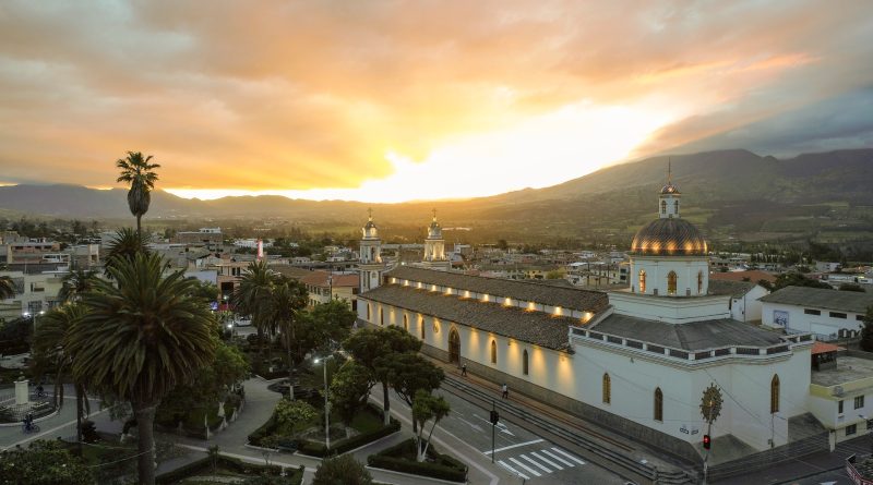
The capital of the country is Quito with 2,215,820 inhabitants (2010).
Ecuador is located in the northwestern part of South America, Ecuador borders Colombia to the north, Peru to the east and south, and the Pacific Ocean to the west; it is crossed by the equator, from which it takes its name.
The capital Quito, in 1970, was declared a World Heritage Site as it has the best preserved and least altered historical center in Latin America.
The most populous city is Guayaquil, while Cuenca, the third most populous city, is also a World Heritage Site, because it is an excellent example of a planned city in the Spanish colonial style.
The archipelago of the Galápagos Islands also joins Ecuador, located about 1,000 km from the coast and particularly rich in endemic species, which in the nineteenth century were deeply studied by the British naturalist Charles Darwin, who was developing the theory of evolution, then described in the famous book The origin of species.
Geography –
From a geographical point of view, Ecuador borders Colombia to the north, Peru to the east and south, while the Pacific Ocean faces the west. In the northern part the territory of the state is crossed by the Equator. From a geographical point of view we can distinguish 4 regions with very different characteristics: the Costa, the Sierra, El Oriente and the island region that includes the Galápagos Islands.
The coast is located in the western part of the country and is characterized by a strip of coastal plains of alluvial origin followed, moving inland, by the mountain range of the Cordillera Costanera (max. 800 m a.s.l.). Once the Cordillera was covered with forests, while now it is exploited with vast plantations of bananas, palms, cocoa and coffee, which extend to the foot of the Andes, which further south is called Cordillera Chongón-Colonche. The thick mangrove vegetation that once characterized the coast has been partially eliminated to make room for crustacean farms in aquaculture.
In the northern part of the coast are the ports of Esmeraldas, the terminal of an oil pipeline used for the export of oil, while the port of Manta was used by the United States Air Force as a support base in the fight against narcotics trafficking.
The southern part of the coast and the peninsula of Santa Elena west of Guayaquil, the most populous city and main port of the state, belong geographically to the desert area that extends towards Peru, while the climate in this area is considerably more arid than in the region northern coastal.
The central part of Ecuador is crossed from north to south by the Andes mountain range; this mountainous territory, made up of numerous plateaus, is called the Sierra. It consists of two parallel chains: the Central Cordillera (also called Cordillera Real) and the Western Cordillera, separated by a wide valley whose average height exceeds 2000 m a.s.l. and in which the main cities of the area are located, including Quito, the country’s capital, located at about 2,800 m a.s.l. on a vast plateau located at the foot of the Guagua Pichincha volcano.
The peaks located in the northern part of the Sierra consist mostly of still active volcanoes. In this area there is one of the highest active volcanoes in the world, Cotopaxi (5,897 m a.s.l.). The highest peak is Mount Chimborazo (6,130 m a.s.l.), an extinct volcano. In the same area there is also the Cayambe volcano, the highest point on the parallel of the Equator. There are also numerous volcanic lakes such as Lake Quilotoa.
The area made up of the plains of the Amazon River basin located east of the Andes is called El Oriente. In this large area (just under 50% of the total surface of the state) lives just under 5% of the total population. The area is covered in impenetrable rainforest. The numerous rivers that flow through this area are all tributaries of the Amazon River: the Rio Napo (850 km), the Rio Coca, the Rio Pastaza, the Putumayo River and the Aguaric. Most of these are born in a very humid Andean region, located at the foot of Cotopaxi.
Finally, the island area that includes the Galápagos Islands located in the Pacific Ocean about 1000 km from the mainland. The archipelago’s official name is Archipélago de Colón, the total area of which is approximately 8000 km², over half of which is occupied by the main island, Isabela. The islands have volcanic origin and, given their natural isolation, are affected by important botanical and faunal endemisms, already reported by Charles Darwin, in the famous HMS Beagle expedition. The observation of the emphasized morphological differences of the islands (especially of turtles and terrestrial birds) led to Darwin’s elaboration of the revolutionary theory of the evolution of species.
As for hydrography, it should be emphasized that most of Ecuador’s waterways arise in the Andes and descend either towards the Pacific Ocean, to the west, or towards the Amazon River, towards the east. In the outermost region of the coast, the smaller rivers are fed by the rains that go from November to May, and can remain dry in the dry season. The longest ones are an exception, which, being born in the high mountains, are fed both by the thaw of the snows on the highest peaks of the mountain range and by the rains that fall in the sierra. The innermost coast, on the other hand, is crossed by perennial rivers, and the abundant rains of the winter season often lead to floods that can sometimes lead to the formation of swamps. The main river system of the Pacific side is that corresponding to the Guayas river basin which includes an area equal to 40,000 km².
On the eastern side, towards the Amazon River, the most important rivers are the Rio Napo, the Putumayo and Pastaza.

Climate –
Ecuador is a country characterized by a variety of climates. This is due more to the difference in the slopes and morphologies than to the extension of the country.
We can divide the climates of Ecuador into four different regions, with contrasting climates and seasons, conditioned by the altitude and ocean currents, as being at the equator the insolation remains the same throughout the year, and it is not irrelevant to the climate of Ecuador. There are only two seasons and are characterized by the abundance and frequency of rainfall: the wet season is called winter and generally has higher temperatures than the dry season, called summer.
The coast, which includes in addition to the coastal area also the internal part of the country to the west of the Andean mountain range, is characterized by a tropical climate and an average temperature of 25 ° C. The wet season, characterized by copious rains, runs from December to May, while the dry season runs from June to November, a period in which temperatures drop by a few degrees, when colder and drier currents blow from the south, i.e. the current of Humboldt, who comes from Antarctica means that the temperature on the coast is on average 5 degrees lower than in winter, when the humid equatorial currents bring heavy rains.
The sierra has a cooler climate due to the altitude; the temperature fluctuates on average between 8 ° C and 20 ° C, with maximum values between 22 ° and 30 °. The rainy season in the sierra generally runs from October to April. From the point of view of a European or any other inhabitant of the temperate zones, the climate of the sierra appears similar to a spring or an autumn, as in Quito itself, where during the day a cool and comfortable wind blows, followed by a night. icy which ends when the sun rises; at that altitude the air is thin, and the difference in temperature between the places in the sun and those in the shade is sensitive.
The east, which includes the Amazon region, has a hot-humid climate and is not influenced by ocean currents, being east of the Andes, but by the climate of the Amazon basin. Average temperatures are 25 ° C and the rainy season runs from April to November, although, unlike in the coast, rainfall is present almost all year round.
Finally, the climate of the Galapagos Islands. Here the climate is more stable than the continental regions of Ecuador, with temperatures constantly between 22 and 32 ° C, although sometimes some cold currents from Peru can drop the temperature by a few degrees.
Flora-
Ecuador is one of the countries in the world with the highest percentage of biodiversity; it becomes part of the 17 so-called megadiverse countries and has the highest concentration of biodiversity per km². In fact, the rainforest and tropical forest biome extends over a large part of its territory, while to the west, near the coast, there is the mangrove forest, and, in the province of Esmeraldas, in an area called Majagual, there are the tallest mangroves in the world. The Galápagos Islands have a great variety of endemic species, once the subject of study by the famous English naturalist Charles Darwin, a study that allowed him to develop the well-known theory of evolution. The islands have become famous all over the world thanks to the original characteristics of its fauna, in particular the turtles. In 1978, UNESCO declared the islands and the marine reserve a World Heritage Site, and in 1986, the sea surrounding the islands was declared a marine reserve. However, some twenty years later, in 2007, UNESCO itself placed the ecosystem in danger due to factors such as the proliferation of invasive species and the indiscriminate increase in tourism and immigration. In 2010, however, UNESCO itself removed the islands from the list of endangered sites after Ecuador showed greater commitment to addressing problems that compromised the integrity of the Galapagos.
To protect this huge natural heritage, Ecuador has established over the years a series of parks and protected areas.
Among these we remember the Yasuní National Park, which in the Waorani language means “sacred land”, extends over an area of 9,820 km and is included between the provinces of Pastaza, Napo and Orellana, between the Napo River and the Curaray River. The park is mainly wooded and is considered a Biosphere Reserve by UNESCO in 1989, and is part of the territory where the Waorani people and the Tagaeri and Taromenane groups are found, tribes never contacted by modern civilization. According to a recent study, Yasuni National Park and the surrounding area are considered to have the largest biodiversity in the world, thanks to its wealth of amphibians, birds, mammals and plants. This park has more species of animals per hectare than the whole of Europe and, always in a single hectare, contains 644 species of trees, which is more than those present in the United States and Canada combined. The site was targeted by oil companies for the large amount of crude oil that was estimated to be present in the subsoil; this and the increase in tourism in the Park area have led to tensions with the indigenous natives of the place, especially with the Waorani, which resulted in violence in 2013 and which led the Waorani themselves to clamor for the intervention of the authority for their protection and for that of their Taromenane “brothers”, still never contacted by civilization.
Other protected areas of particular interest are the Sangay National Park, a World Heritage Site since 1983, the El Cajas National Park, the Podocarpus National Park and the Llanganates Park, located near Baños.
Ultimately, to understand Ecuador’s huge floristic heritage, it is estimated that the total number of plants is between 16,000 and 18,000 species; of these, about 230 families are vascular plants (ferns, lycophytes and various plants belonging to the genus equisetum). The Amazon rainforest represents an extremely rich ecosystem: in just one hectare of Ecuadorian forest there are more than 300 species of trees and climbing plants, most of which are made up of palm trees over 30 m high.
The country is also rich in trees from the finest wood, such as mahogany, ebony, oak, laurel, cinnamon, breadfruit, balsam, almond and some species of flowers such as magnolias and orchids.
The coasts of the country are characterized by a rich ecosystem whose survival, however, is in grave danger: mangrove forests are almost completely disappearing to make way for shrimp farms.
Fauna –
The fauna of Ecuador, as mentioned, is abundant and heterogeneous; among the large species there are bears, jaguars and lynxes; in the coastal areas there are different types of reptiles, including lizards, snakes and crocodiles.
The real wealth of Ecuador, in terms of biodiversity, is found in the Galapagos Islands, a singular habitat thanks to the abundance of unique species of flora and fauna in the world, such as the famous giant tortoises and iguanas, true symbols of the islands.
Guido Bissanti