
Hydrographic basin
Hydrographic basin
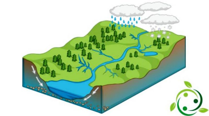
The term hydrographic basin, or even river basin or catchment basin, means a section of territory within which the waters flow into a stream that can be torrential or fluvial.
The limits of a basin are defined by the watershed line, which coincides with the ridge line of the mountain ranges.
The shape and size of an ideographic basin are generally determined by the geological characteristics of the area, while the branching of the ideographic network, i.e. the density of the smaller waterways, also depends essentially on the regime of precipitation, the types of soil and of vegetation and, increasingly, also from human activities.
In the water catchment area, the portion of the territory whose waters, due to the distribution of the slopes, flow towards the sea, is called the exoreic zone.
However, there are also endorheic and areic areas.
In endorheic areas, surface waters end in lagoons or inland lakes not connected to the oceanic system, or disappear underground. Examples of these areas are the large North American or Central Asian inland basins (the Caspian Sea system, the Aral Sea in Asia, the Jordan-Dead Sea in Israel, many of the tectonic lakes of South-East Africa) and the karst systems (Trieste Karst, Piani del Gran Sasso, Apulian and Lucanian Murge), where surface waters percolate into the subsoil where they feed a hypogean (i.e. underground) hydrographic network.
In the areiche areas, however, there is no hydrographic network; the sliding on the surface is absent, except in the rare moments of precipitation (for example the deserts).
The size of the river basins can vary from a few km2 up to large basins, such as that of the Amazon River which covers an area of 7 million km2.
Furthermore, most of the main river basins are formed by the union of several sub-basins represented by the river basins of the individual tributaries of the main watercourse. For closed basins (lakes or inland seas) the river basin coincides with the sum of all the river basins that flow, directly or indirectly, to the lake or sea considered.
Definitions –
The two-dimensional description of a hydrographic network is carried out on the basis of its representation in the plane; this representation is based on certain topological properties that can be easily described and classified. Regardless of the type of scheme adopted, it is possible to identify general topological definitions:
– external nodes (or sources) are defined as those nodes from which only one auction originates;
– internal nodes (or junctions) are defined as those nodes consisting of the points where several auctions meet;
– internal elements are defined as the elements that connect internal nodes and joints or internal nodes themselves;
– external elements are defined as the elements that connect an internal node immediately downstream with a source;
– the network number is defined as the total number of sources;
– topological distance is defined as the number of branches between the distance from the source to the outlet of the network;
– topological level is defined as the topological distance between the upstream node and the outlet of the network;
– the maximum topological distance is defined as the diameter of the net.